GIS ObjectLand v.2. 6. 2003
Advertisement
Description
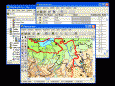
GIS ObjectLand is a universal Geographic Information System for Windows.
Key features:
- creation of vector-raster maps with arbitrary structure of layers and feature types;
- creation of themes. Theme is a user presentation of a map;
- control of displaying features depending on the chosen scale;
- spatial data input and editing by assigning feature coordinates and also by interactive drawing with mouse or...
Read more
- Rate:
- Release Date:02/16/2012
- License:Shareware
- Category:Database Solutions
- Developer:Radom-T
- Downloads:100
- Size:23.54 Mb
- Price: $99.00
To free download a trial version of GIS ObjectLand, click here
To visit developer homepage of GIS ObjectLand, click here
Advertisement
Screen Shot
Click on a thumbnail for the larger image.

System Requirements
GIS ObjectLand requires Win95, Win98, WinME, WinXP, WinNT, 4.x, Windows2000, Windows2003.
GIS ObjectLand v.2. 6. 2003 Copyright
Shareware Junction periodically updates pricing and software information of GIS ObjectLand v.2. 6. 2003 full version from the publisher using pad file and submit from users. Software piracy is theft, Using crack, password, serial numbers, registration codes, key generators, cd key, hacks is illegal and prevent future development of GIS ObjectLand v.2. 6. 2003 Edition. Download links are directly from our publisher sites. Links GIS ObjectLand v.2. 6. 2003 from Bittorrent, mediafire.com, uploadfiles.com, hotfiles.com rapidshare.com, megaupload.com, netload.in, storage.to, depositfiles.com and other files hosting are not allowed. The download file is obtained directly from the publisher, not from any Peer to Peer file sharing applications such as Shareaza, Limewire, Kazaa, Imesh, eDonkey, eMule, Ares, BearShare, Overnet, Morpheus, BitTorrent Azureus and WinMX.
Review This Software
More GIS ObjectLand Software
Advertisement
ObjectLand v.2. 7. 2006
GIS ObjectLand processes data organized as geoinformation database (GDB). Basic GDB components are maps, themes, tables, queries, external databases, layouts, users, and styles.

Icons-Land Vista Style GIS/GPS/MAP Icon Set v.2.0
Vista Style GIS/GPS/Map Icon Set is of perfect design quality. Being represented in 7 sizes, icons can be widely used in local service applications, GPS tracking and GIS applications, and any kind of mapping applications.
Quantum GIS Tethys v.1.5-r13926-1
The Quantum GIS Tethys repository contains a lot of software from OSGeo projects. Quantum GIS Tethys and all dependencies are included, along with Python, GRASS, GDAL, etc.
My World GIS v.4. 1. 2011
My World GIS™ is a Geographic Information System (GIS) designed specifically for use in middle school through college classrooms.
Quantum GIS v.1.8.0
Cross-platform and user friendly Open Source Geographic Information System (GIS). Quantum GIS (QGIS) is a user friendly Open Source Geographic Information System (GIS) that runs on Linux, Unix, Mac OSX, and Windows. QGIS supports vector, raster,
Canvas GIS Advanced (Mac) v.9.0.4
About Canvas GIS Advanced (Mac)Adds native support for Geographic Information System (GIS) data to Canvas.
AvisMap GIS Engine
AvisMap GIS Engine is a comprehensive SDK for the development of custom GIS applications and solutions. This SDK provides several ActiveX (OCX) controls which support Visual Basic, VB.NET, C#, Visual C++ and other ActiveX compatible programming languages,
Total GIS Converter v.1.5
Total GIS Converter is a powerful converter of GIS files. It converts AEP, GRD, ADF, E00, FLT, APR, SHP, DXF and many other GIS formats to TIFF, PNG, JPEG, BMP. Along with conversion it can scale and resize your files. Download your free copy now!
AvisMap GIS Engine Sample Projects v.5.0
AvisMap GIS Engine is the basic development platform for AvisMap GIS suites, which is a new generation component GIS development platform for GIS application developers.
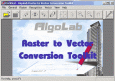
Algolab Raster to Vector Conversion CAD/GIS SDK v.2 55
Software development kit for CAD/CAM/ GIS and graphic software developers. Converts from raster to vector and refines architect, mechanical, tech drawing, maps, math graphs, graphics for books and journals and more.

Grass GIS for Mac OS X 6.4.1-3 v.3
Commonly referred to as GRASS, this is a free Geographic Information System (GIS) used for geospatial data management and analysis, image processing, graphics/maps production, spatial modeling, and visualization.
Other products of this developer Radom-T
ObjectLand v.2. 7. 2006
GIS ObjectLand processes data organized as geoin... external databases, layouts, users, and styles.